
Inside the "Washing Machine": Cold Front Flips the Holiday Weekend Script

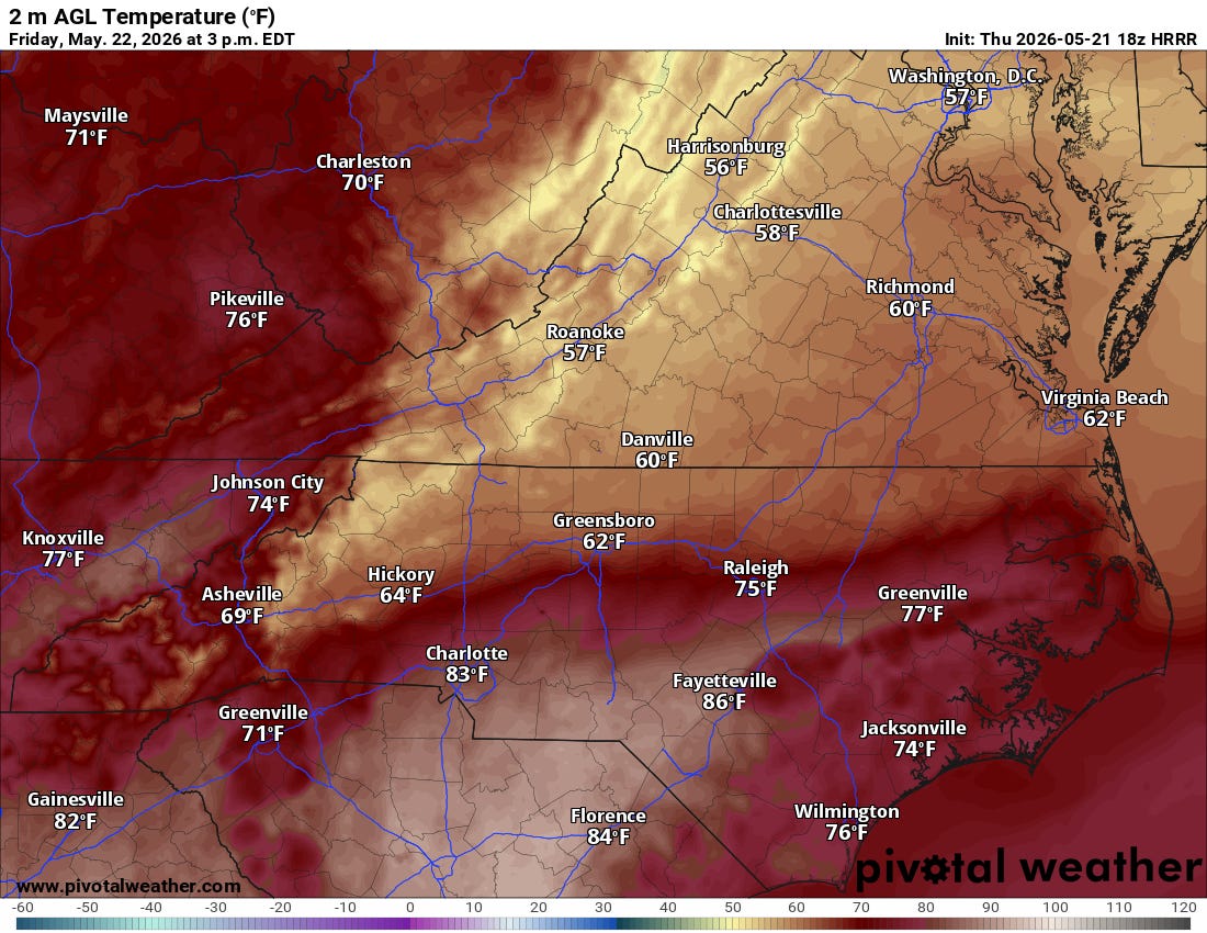
This evening, scattered showers and thunderstorms will become more widespread across our area as a cold front slowly pushes southeast through central Virginia and into North Carolina.
If you are south of I-64, keep an eye on the sky: the Storm Prediction Center has placed this corridor under a Marginal Risk for severe weather. While the overall atmospheric energy is on the lower side, a few stronger storms could still kick up damaging winds and brief, blinding downpours.

Because the winds aloft are incredibly weak, these storms are going to be slow movers. We are watching the potential for “training”—where multiple storms line up and roll over the same neighborhoods like train cars. The weather models are a bit split on where the heaviest rain bands will set up (some point to the Richmond Metro, while others target interior southeast Virginia and northeast North Carolina). Ultimately, the front’s current position poses the highest threat south of I-64.

The silver lining? We are in a stubborn drought, and our soils can handle a lot of water right now, meaning widespread flash flooding isn’t highly likely. However, if you live in a low-lying or urban area, watch out for localized street flooding. The storm threat will steadily wane overnight as the front clears the area, ushering in cooler, much more stable air.

The Memorial Day Weekend Forecast: A Tale of Two Air Masses
If you have outdoor plans for the holiday weekend, you’ll want to keep checking the radar. An increasingly unsettled pattern is taking shape, and it’s bringing a classic meteorological phenomenon known as CAD—Cold Air Damming (often called “the wedge”).
High pressure building into New England will funnel cool, damp marine air from the Atlantic straight into our region, trapping it against the mountains.
Here is what to expect over the holiday weekend:
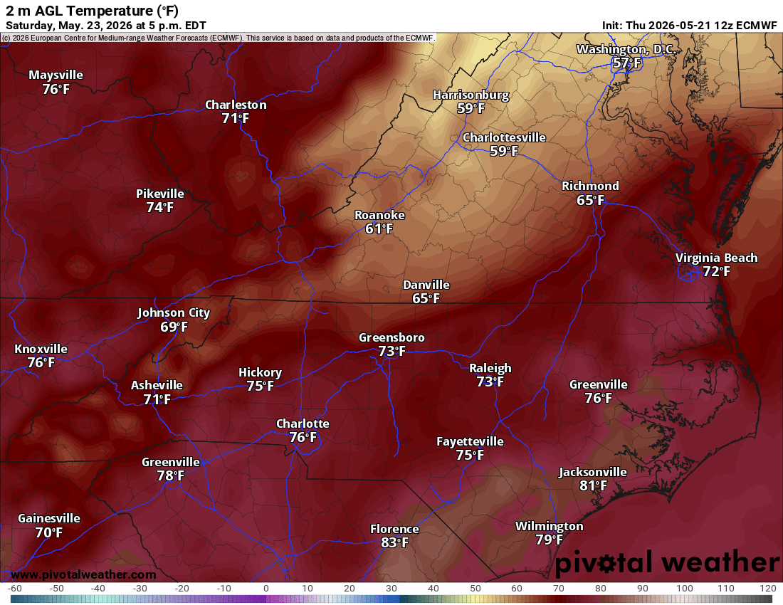
Friday: A total reality check. Temperatures will struggle, with highs ranging from a brisk 60°F in the north to the low- to mid-70s in northeast North Carolina. Expect a gray day dominated by light, stratiform rain (steady, widespread rain rather than stormy downpours) and a persistent drizzle. The good news? There is virtually no risk of thunder or severe weather on Friday.
Saturday: The “wedge” of cool air might prove stubborn. A warm front will try to lift north, creating a massive temperature contrast across our region. While extreme southeast Virginia and northeast North Carolina could pop into the lower 80s, portions of the Piedmont may stay stuck in the lower 60s under a blanket of low clouds and a chilly northeast breeze.
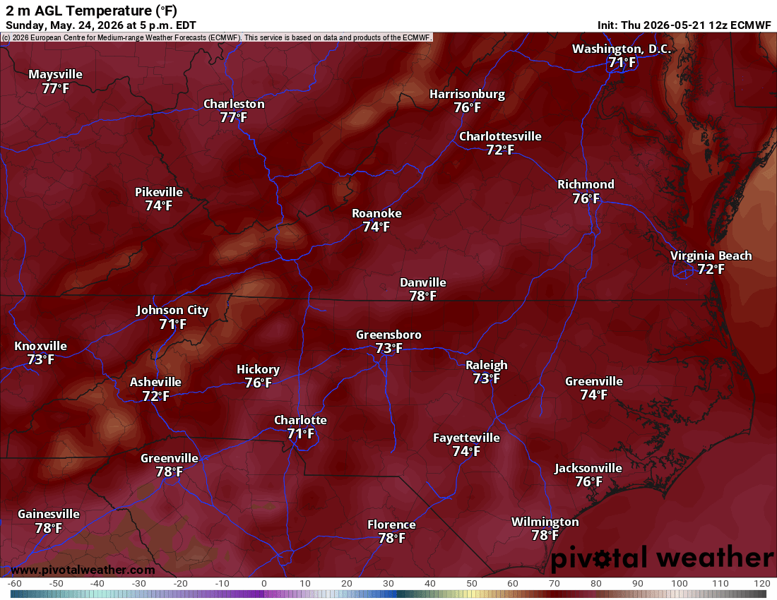
Sunday & Monday: The warm front should finally win the battle later Sunday into Monday, eroding the cool air and bringing a quick warmup. However, the front is expected to stall out over the northern parts of our area. This means while the weekend won’t be a total washout, we have a chance of rain virtually every single day through the middle of next week.


When all is said and done, weather models suggest we could pick up anywhere from 1.0 to 2.5 inches of rain through Monday. Given how dry it has been lately, this holiday weekend’s dampness will be incredibly beneficial for our lawns and local crops.

Marine & Beach Outlook: “Washing Machine” Conditions
Planning to head to the coast or take the boat out? Pack your patience. A Small Craft Advisory is in effect for the Chesapeake Bay, lower James River, and coastal waters north of the VA/NC border.
Expect northeast winds of 15–20 knots with gusts up to 25–30 knots through Friday evening. This will churn up 5 to 7-foot seas in our northern coastal waters. While the winds will relax and become highly variable by Saturday night, those rough 5 to 7-foot waves will likely linger into Sunday evening.

For beachgoers, this persistent easterly swell will create a chaotic “washing machine” effect at all local beaches throughout much of the holiday weekend. Combined with low clouds and patchy fog, it’s shaping up to be better weather for a cozy indoor book session than a sunbathing excursion.

Check out rvaweather.net for the latest, and as always, stay safe out there!

Are your holiday weekend plans officially ruined, or are you just celebrating the fact that you don't have to water your lawn for the next week? Drop your location and tell me what the radar is looking like in your backyard!